Mathikettan Shola National Park
Location - Poopara village of Udumbanchola Taluk, Idukki District, Kerala
Best time to visit - November to March
How to reach:-
Train - Thenni Railway Station (59.8 km)
Flight - Cochin International Airport (121 km)
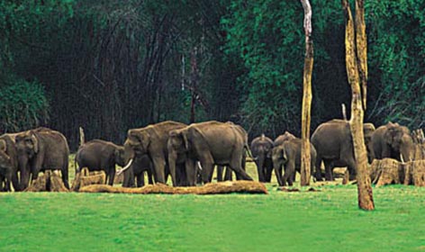
The literal meaning of Mathikettan in Tamil is ‘mind confuser’, which implies that one might lose track of the way after entering the forest due to the confusing paths. The Mathikettan Shola National Park is located between the Eravikulam National Park and Pampadum Shola National Park and The Anayirangal Dam is a visual treat near the national park. Spread over an area of 12.82 sq km, the national park is a biodiversity hotspot, housing diverse species of flora and fauna. Uchillkuthi Puzha, Mathikettan Puzha, and Njandar streams emerge from the Mathikettan hill ranges and form the tributaries of the River Panniyar. The national park also plays the role of a significant corridor for the elephants in South India. They arrive at Mathikettan Shola National Park from the Munnar Division.
The national park is about 2 km away from the Kochi-Madurai National Highway and 10 km from the Munnar-Kumily State Highway and 37.4 km from Munnar. The park experiences cloudy and misty weather almost throughout the year and receives 2000-2700 mm of yearly rainfall and the temperature ranges between 10°C to 40°C. The undulating terrain and the multiple and confusing paths of the forest serve as the best location for adventure seekers to trek. The park is also a paradise for birdwatchers and photographers. The winding paths of the Mathkettan forests not only confuse the trekkers or the explorers but the elephants also get puzzled and separate from their group and get stuck in the jungle.
The trekking trails are organised by the forest department through the dense forest. The trek route commences from Poopara and is destined for Mathikettan Shola via Munnar. The picturesque views of the region along with the glimpses of the wild animals and birds are the prime attractions throughout the trek. Trekking through the Shola forests, accompanied by other eco-tourism activities like border walking, and staying at log huts are jointly arranged by the Forest Department and the Eco-development Committees (EDCs) of the local tribal communities.
History - The woodlands of Mathikettan were declared as a Reserved Forest in the year 1897 by the Government of Travancore. In November 2003, the area got the recognition of a National Park to safeguard the population of wildlife and affluent biodiversity. Before being declared a national park, some portion of the Mathikettan Shola area was leased out for Cardamom production. As per the reports of the Travancore Government Journal of August 24, 1897, the Mathikettan region was a part of the Cardamom Hummock Region or CHR.
Flora - Moist deciduous forests, West coast tropical evergreen forests, West coast semi-evergreen forests, Grasslands, Litsea wightiana, Bhesa indica, Chionanthus ramiflorus, Callophyllum austro-indicum, Syzygium gardneri, Ferns, Orchids, Lichen and Mosses.
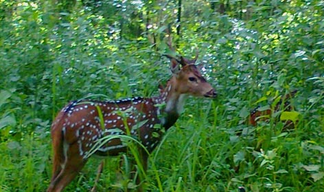
Fauna - Tigers, Elephants, Panthers, Flying squirrels, Giant grizzled squirrel, Nilgiri Tahr, Spotted deer, Wild dogs, Jungle cats, Sambar, Gaur, Turtles, Crocodiles, Rat snakes, Vipers, King Cobra, Pythons, Lizards, Butterflies and Birds.
Kerala Tour Packages:
- Amazing Kerala Budget Tour
- Best Magical Kerala Tour
- Exotic Kerala Tour
- Offbeat Kerala Family Package
- Kerala Hills Backwater Beaches
- Through the Hills and Backwaters
- Beaches and Backwaters of Kerala
- Enchanting Hill Stations Tour
- Relaxing Beach Vacation
- Beach Excursion of Kerala
- Kerala Tamilnadu Tour
- Tamilnadu tour with kerala
- Kerala and tamilnadu package
- Karnataka and Tamil Nadu